
Cronkite News has moved to a new home at cronkitenews.azpbs.org. Use this site to search archives from 2011 to May 2015. You can search the new site for current stories.
Experts: Orbiting observatory mapping soil moisture will benefit Arizona
A recently launched NASA satellite that is gathering data on the planet’s soil moisture will benefit Arizona decision-makers from the halls of government to fields where farmers need to know when to plant, a project scientist says.
The Soil Moisture Active Passive observatory, or SMAP, is orbiting the Earth after its launch at the Vandenberg Air Force Base in California on Jan. 31. It will produce global maps over three years.
Susan Moran, a Tucson-based research hydrologist for the U.S. Department of Agriculture who was part of the scientific team that made the satellite a reality, said this is key to more accurate weather prediction, as current methods of measuring soil moisture are often inaccurate.
“It’s really been a dream of not only the scientists but also the users, the weather forecasters and the people that are monitoring drought and even looking at food security in Africa,” Moran said. “It’s just been a dream for a very long time.”
And people all over the world will have access to the data that SMAP will provide. Moran said that right now a group is trying to use data to measure New York City’s water supply, and a project in Germany is using radar and SMAP data to improve sea ice mapping to make navigation safer.
“And in the United Arab Emirates, they’re using soil moisture information to predict dust storms, like the ones we have in Phoenix,” she said.
Moran said research on dust storms in Africa and the Middle East is showing that better understanding of soil moisture leads to better predictions of the extent and intensity of dust storms.
“With that, it will help with traffic planners, health issues and people that need to stay indoors, that sort of thing,” she said.
Moran said John Deere Corp. is using soil moisture to help farmers understand when they can bring heavy equipment into their fields to plant.
“Not only would a farmer be able to look at the weather and drought related to their own fields … a cotton farmer in Arizona will be able to look at the soil moisture in India and China related to cotton crops, and the (U.S. Department of Agriculture’s) Foreign Agricultural Service is going to give them estimates of cotton yields in those countries, so they can better know when to harvest and how to market,” Moran said.
Another benefit is to flood forecasting, including flash flood guidance, Moran said. She said a group in San Diego uses soil moisture data to predict flash flooding in Africa.
“That would be something we could use definately use in Arizona,” she said. “All these groups will have free, easy access to soil moisture.”
What is @NASA's #SMAP satellite and what could it do for #Arizona? I spoke with a hydrologist on the team to find out. @cronkitenews
— Becky Brisley (@becky_brisley) February 19, 2015
State Climatologist Nancy Selover said that with Arizona’s drought, the satellite will be especially helpful in giving a good indication of how quickly the soil dries after rain.
“We don’t get that much rain, and knowing how quickly the soil dries back out is really helpful,” Selover said. “We need impact information. We don’t have rain gauges everywhere, we have a lot of places where we don’t have any eyes on the ground. It will be helpful to fill in the gaps.”
Those gaps in between points of measurement are currently being estimated. With more accurate information, Selover said that it will be easier to understand the state of Arizona’s drought.
“Drought is a difficult thing to deal with because if there’s no impact, it’s hard to say there’s drought,” she said.
The data will be available after it’s been validated in six to nine months. When it is, Moran said, it will have a big impact.
“It’s really going to make a giant difference in the way people around the world make decisions,” she said.
VIDEO STORY
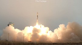

 observatory onboard is seen in this long exposure photograph as it launches from Vandenberg Air Force Base in California on Jan. 31.")
A United Launch Alliance Delta II rocket with the Soil Moisture Active Passive (SMAP) observatory onboard is seen in this long exposure photograph as it launches from Vandenberg Air Force Base in California on Jan. 31.
Photo by NASA/Bill Ingalls

|
|
|
|
RSS |
Contact |
|
OTHER ARIZONA NEWS SOURCES |
||||
| Phoenix Newspapers | TV News | Arizona Politics on the Air | AZ News: National Outlets | Other State News |
|
Arizona Capitol Times Arizona Republic East Valley Tribune Independent Newspapers Phoenix Business Journal Phoenix New Times |
3TV CBS 5 FOX 10 12 News ABC15 |
KJZZ Horizon (Eight) Newsmaker Sunday (FOX10) Politics Unplugged (3TV) Sunday Square Off (12News) |
FOX News NBC News New York Times NPR Politico |
Arizona Daily Star (Tucson) Daily Courier (Prescott) Daily Sun (Flagstaff) KTAR (Phoenix) The Sun (Yuma) |
WALTER CRONKITE SCHOOL OF JOURNALISM AND MASS COMMUNICATION AT ARIZONA STATE UNIVERSITY 